Weather maps have revealed the exact date that snow and fast winds are predicted to batter the UK. Meteorological winter is officially upon us, and with it, months of chilly and potentially treacherous conditions. Brits will be bracing for harsh breezes and sub-zero temperatures this month, and into January and February, with the warm, comforting sunrays of spring in the seemingly distant future. According to forecaster WXCharts, the country is expected to experience snow and strong winds of up to 63mph on Christmas Eve.
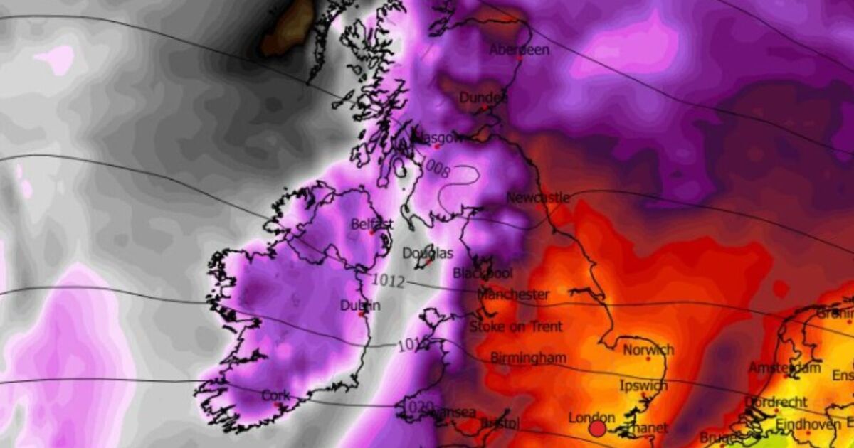
Maps suggest the highlands of Scotland, above Glasgow and to the west of Dundee and Aberdeen will see snow coverage. The map below shows that up to seven centimetres (2.7 inches) of snow can be expected. Meanwhile, wind charts are covered in purple – signifying speeds of about 85 to 110km/h – and red – denoting around 60 to 80km/h – patches, suggesting very intense gusts, especially in Scotland, Northern Ireland and parts of Wales. The general rule seems to be that the further south east you live, the less these conditions will impact you on this occasion.
Seperately, the Met Office has issued its own long-range forecast for December 24 to January 7.
Its experts say: “Changeable conditions are likely to give way to slower moving weather patterns through this period, however the detail remains highly elusive.
“This means that whilst outbreaks of rain and showers remains probable at times there will also be drier interludes, which may be more prolonged than of late.
“Some spells of strong winds are possible but in the drier periods frost and fog becomes likely.”
They concluded: “On balance temperatures will likely be near normal with any snowfall most likely in the north over higher ground.”
The national weather service previously explained it’s difficult to predict snow in the UK, especially weeks in advance.
There are currently warnings in place for wind across Scotland, a lot of Wales, parts of northern England and Northern Ireland. Amber warnings warn residents that there is potential for large waves and beach material being thrown onto sea fronts, coastal roads and properties.
In addition, roads, bridges and railway lines may close, with delays and cancellations to bus, train, ferry services and flights, and power cuts could occur and affect other services, such as mobile phone coverage.
Specialists also say damage to buildings and homes is possible, with roofs blown off and power lines brought down, and flying debris could result in a danger to life.
It comes after strong winds of around 50mph were forecast across Wales and the south west of England from 10pm on Monday until 4pm today.
The Met Office warned that gusts of up to 70mph were possible along some coastal areas and high ground in the northwest of Wales.