England’s mild winter is set to come to a bitter end within weeks as weather maps predict up to 37cm of snow will fall, with temperatures plummeting well below freezing.
The cold blast is set to move in on January 9 in England, and Brits will notice a sharp shift between Thursday and Friday, with forecasts switching from around 10-16cm of snowfall to more than 20cm across the north, and a staggering 31cm in some parts, according to WXCharts. Maps predict temperatures will also plunge to an icy -8C, which could be accompanied by cold northerly winds, creating potentially hazardous driving conditions.
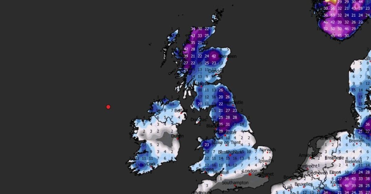
England will be covered from London to Newcastle, but the north will be the worst hit area, with around 18cm of snow forecast over Newcastle, 28cm in Manchester, and up to 31cm in Yorkshire, charts suggest.
The south and Midlands will not be spared, with Birmingham set to be covered in 16cm of snow, which will stretch across into Wales, according to predictions.
Forecasts suggest Norfolk may get a light dusting of 2cm, the same as parts of Cornwall, but London and the south coast will miss out.
The following day it will get even colder, dropping to -11C at midday, when up to 33cm of snow has been forecast in Yorkshire, WXCharts says. Again, the south coast will remain dry, but heavy snow will make its way across the Midlands from the west, the site adds.
Wales and Scotland will also apparently bear the brunt of the icy blast. In northwest Wales, up to 32cm of snow has been forecast, indicated by dark purple on the maps. Scotland will also be battered with snow, with up to 47cm predicted at the very tip of the country, forecasters suggest.
Northern Ireland has also been forecast snow, although far less than England, with a maximum of 14cm predicted to fall.
WXCharts maps indicate the wintry conditions will stick around for the weekend, with even more predicted to fall the following day.
The Met Office acknowledges that snow is hard to predict, and its own separate forecast differs from that of WXCharts. But it has also predicted that cold northerly winds may become dominant across the UK in the first week of January, bringing “wintry showers (often of snow)” to many coastlines and exposed areas just inland.
Its long-range forecast from January 2 until January 11 said: “There are likely to be some more coherent bands of rain, sleet and snow working south, and these may bring a risk of more prolonged wintry precipitation affecting some inland areas.
“Towards the second half of this period, slightly milder conditions will attempt to move in from the west.”