
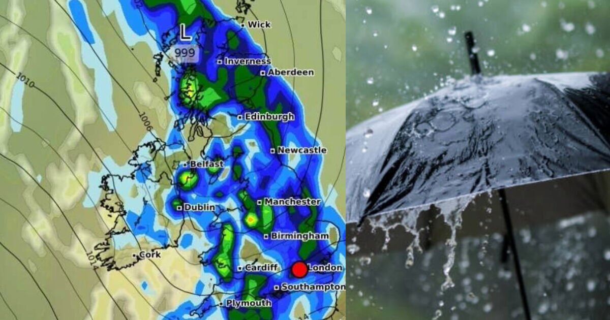
Almost all of Britain could be soaked by downpours at the start of this Bank Holiday weekend. A new weather map by WXCharts.com shows a wall of rain could stretch nearly 600 miles from Land’s End in Cornwall to almost John O’Groats in the far north-east of Scotland.
Britons have been enjoying some fine weather recently which has seen this spring on track to be the driest on record following some warm and dry conditons. However, the new weather map released on Monday suggests some wetter weather is potentially on its way on Saturday afternoon. It shows large parts of the country could face downpours.
Nearly all of England is expected to see rain, including major cities like London, Birmingham, Manchester, Newcastle and Liverpool.
Much of the rain will be less than 1mm per hour but Cheshire could see the heaviest showers of up to 4mm per hour.
The rain across England is set to stretch from Cornwall, across the south coast, south-east and East Anglia.
London and the Home Counties will likely see rainfall, as well practically all of the Midlands and north of England.
Its a similar story in Scotland where widespread rain is predicted.
Scotland’s west coast is expected to see the heaviest train, where some areas could face 2-3mm per hour.
Rain is expected to fall right up into Scotland’s north-east county of Caithness but is not expected to reach John O’Groats.
Edinburgh is expected to see rainfall but Glasgow and parts of Lanarkshire and Renfrewshire could remain dry, the weather map shows.
The whole of Wales is predicted to see rain, with central areas expected to be the heaviest downpours between 1-2.5mm per hour.
Much of Northern Ireland is expected to stay dry, although Londonderry and Belfast could see some lighter showers.
County Down is expected to the most rain with up to 3mm per hour possible, according to the weather map.
The Met Office says spells of potentially heavy rain are possible.
In its long range UK forecast for May 23 – June 1, it said: “As we head into the bank holiday weekend and following week, a change in weather type is expected.
“More unsettled conditions are likely to develop, with weather systems moving in from the Atlantic. The change is likely to happen first in the northwest, probably later on Friday or through Saturday.
“This will see frontal systems bringing spells of rain, perhaps heavy at times, with a risk of strong winds in places, and these conditions will gradually spread across the UK as we go through the weekend. Drier and brighter intervals are likely between systems but with showers, some of which could be heavy / thundery.
“Temperatures will probably be close to average, perhaps slightly above at times, but will feel fairly cool in the often strong winds.”


