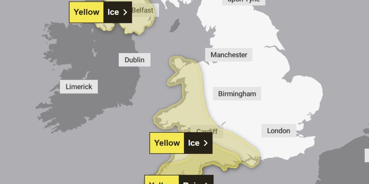
The Met Office has issued yellow weather warnings for ice and rain spanning large parts of the UK, with the alerts running from this afternoon through to Tuesday morning.
Temperatures are forecast to plunge to -2C, bringing a bitterly cold start to the week for millions of residents.
The warnings cover London and the South East, the South West, Wales and Northern Ireland.
In certain areas, potential flooding has been classified as posing a “danger to life” by forecasters.
The severe weather follows closely on the heels of Storm Chandra, which caused widespread disruption across the country just last week.
Residents across these regions should exercise caution when travelling, particularly on surfaces that have not been treated.
Roads, pavements and cycle paths all present potential hazards as wet ground turns to ice.
Recent rainfall has left many outdoor surfaces damp, and as temperatures fall close to or below freezing point this evening, these areas are expected to become treacherous.

Roads, pavements and cycle paths all present potential hazards as wet ground turns to ice
|
MET OFFICE
The warning applies equally to pedestrians and cyclists as it does to motorists.
Those venturing out are urged to take extra care, with the risk of slippery conditions persisting throughout Sunday night and into Monday morning across all affected areas.
The Met Office explained: “With wet surfaces following recent rain, and temperatures falling close to or below freezing, icy patches will be possible on untreated surfaces for a time on Sunday night into Monday morning.”
Forecasters added that cloud cover moving in from the east during the later hours may help temperatures recover somewhat.
However, western areas face a prolonged cold spell, with ice remaining a concern through the Monday morning rush hour.
Drivers heading to work are advised to check conditions before setting off.
An additional hazard comes in the form of freezing fog patches, which could reduce visibility and make journeys even more perilous.
Alongside the ice warnings, forecasters have cautioned that up to 50mm of rain could fall in some areas, potentially triggering flooding severe enough to pose a danger to life.
The South West faces a continued rain warning extending into Tuesday morning.
Those living in affected regions are being encouraged to plan ahead and assemble emergency flood kits in case conditions deteriorate.
Motorists should verify road conditions before embarking on any journeys, as icy surfaces combined with heavy rainfall could create particularly hazardous driving conditions.
The combination of freezing temperatures and substantial precipitation means travel disruption remains highly likely throughout the warning period.
The current warnings arrive as the UK continues to recover from the devastation wrought by Storm Chandra, which swept through the country last week.
That storm brought torrential downpours that left numerous regions submerged under floodwater.
The chaos extended beyond flooded streets, with road closures implemented across affected areas and flights cancelled at airports.
Residents who endured that disruption now face the prospect of further travel difficulties as the new weather system moves in.
The back-to-back severe weather events underscore the challenging conditions facing communities across London, the South East, South West, Wales and Northern Ireland as February begins.