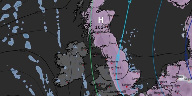
An Arctic blast looks set to bury much of Britain under snow, with a weather map showing the mercury plunging to -0 in several areas across the country. Most of Scotland and England, with the exception of a few areas in the West Midlands and the South West, will be covered in snow on Wednesday, January 7, according to new weather charts.
Maps generated on December 26 by WXCharts, which uses Met Desk data, suggest snow will already be covering several counties in Scotland, as well as small areas across England, on January 6. But another map suggests a blast coming from the Arctic will hit most of England and southern Scotland the following day.
If the maps are correct this far ahead, cities as far south as Brighton will see snow falling on January 7.
A snow depth map suggests that, by 6pm that day, as many as 5.1 inches of snow could have fallen in two regions – Scotland and the South East.
Temperatures will also be below freezing in several areas, another map shows, with Scotland looking particularly cold with areas being hit by -6C to -8C. In England, temperatures will be slightly milder, the map suggests, with areas between the North West and Yorkshire and the Humber experiencing between 0 and -3C, while the south-east of England could see temperatures between 1 and -1.
The maps suggest that Wales, Northern Ireland and the South West will be untouched by snow, and will experience temperatures between 0 and 10C.
While WXCharts maps suggest snow may sweep across the country, the Met Office is more cautious with forecasting it.
In its long-range forecast looking at dates between December 31 and January 9, the forecaster said: “High pressure is likely to be centred to the west or northwest over the North Atlantic through this period with low pressure to the east. Slowly evolving weather patterns are therefore most probable through this time. However, around the turn of the year, an area of low pressure may move through the North Sea bringing a period of wetter and windier weather, especially to the north. With cold air close to the UK, some wintry hazards are possible in places.
“Into January more settled conditions with colder and drier than average conditions are most probable. There will however be some periods of rain or showers and windier spells. Temperatures will probably be below average for this period overall and so wintry hazards remain a possibility in places.”
The Met Office previously explained forecasting snow in the UK is more complex than in continental Europe due to rapidly-changing conditions. Its website read: “Small variations in temperature or wind direction can mean the difference between rain, sleet or snow. Meteorologists use high-resolution models to predict precipitation type, but these models can struggle with marginal situations where temperatures hover around freezing.
“Forecasters also consider factors such as precipitation intensity. Heavy bursts of precipitation can cool the air near the surface, increasing the chance of snow. Conversely, lighter precipitation may melt before reaching the ground. This fine balance makes snow forecasting one of the most uncertain aspects of UK weather prediction.”


